North American Regional Climate Change Assessment Program
    Home Data Overview
 
  PROGRAM
About NARCCAP
About Data
Contact Us
  RESOURCES
For PIs
For Users
    Access Data
  User Directory
  Contributions
  Acknowledgements
  RESULTS
Output Data Catalog
General Results
    NCEP-Driven RCM Runs
Climate Change Results
CRCM+CCSM
CRCM+CGCM3
ECP2+GFDL
ECP2+HadCM3 NEW!
HRM3+GFDL
HRM3+HadCM3
MM5I+CCSM
MM5I+HadCM3 NEW!
RCM3+CGCM3
RCM3+GFDL
WRFG+CCSM
WRFG+CGCM3
  SPONSORS
 
Data Overview
 

NARCCAP data is stored in CF-compliant NetCDF format. Filenames are of the form VariableName_ModelName_Driver_Time.nc.

  • VariableName is the IPCC/CF-convention Variable Name as listed in the data tables
  • ModelName is the 4-character RCM identifier
  • Driver is either "ncep" or the name of the driving GCM
  • Time is the starting time of the file, in the form YearMonthDayHour.
Each file contains data for a single variable and covers 5 years, ending in a year that ends in 0 or 5. (Files covering the beginning and ending of the run may not contain a full five years of data.)

So, for example, tas_RCM3_ncep_1981010103.nc contains data for variable tas from the RegCM3 regional model driven with NCEP boundary conditions starting at 03 GMT on January 1st, 1981 and ending at 00 GMT on January 1st, 1985. All times are UTC (Universal Coordinated Time) or, equivalently, GMT (Greenwich Mean Time).

Useful Links

NetCDF

NetCDF is a data format for storing array-oriented scientific data, particularly geophysical data. It is highly portable, widely-understood, and has built-in metadata that makes the files self-describing.

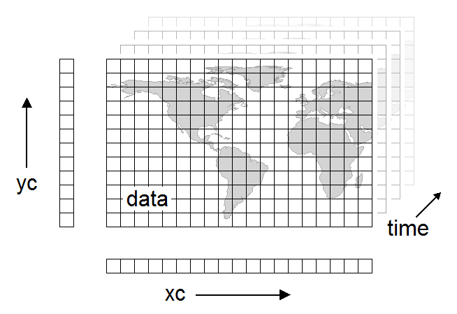
The main data array has associated coodinate arrays, xc, yc, and time, for each of its dimensions. Time is an unlimited or record dimension (important for some tools). Each variable in a NetCDF file can have attributes associated with it.

A Note on Levels

Some variables are provided at a particular height above the earth's surface. For example, surface air temperature is recorded at "screen height", 2 meters above the ground. Also, the 3-D variables we provide are disaggregated by level, with values at different pressure levels stored in separate files.

In these cases, instead of giving the data an additional dimension for the z-coordinate, the height is recorded as a scalar coordinate variable. This is single-valued variable in the file referenced by name in the "coordinates" attribute of the main data variable. It is usually named "level".

NetCDF Header

Here is an example of the headers for a NetCDF file: pr_WRFG_1979090103.nc.head.txt -- produced by ncdump -h pr_WRFG_1979090103.nc

Useful Links

http://www.unidata.ucar.edu/software/netcdf/ -- The NetCDF homepage

 
©2007 UCAR   |   Privacy Policy   |   Terms of Use   |   Site Map   |   top of page    
The National Center for Atmospheric Research is sponsored by the National Science Foundation. Any opinions, findings and conclusions or recommendations expressed in this material do not necessarily reflect the views of the National Science Foundation.